The Python Book
All — By Topic
2019 2016 2015 2014
angle
argsort
beautifulsoup
binary
bisect
clean
collinear
covariance
cut_paste_cli
datafaking
dataframe
datetime
day_of_week
delta_time
df2sql
doctest
exif
floodfill
fold
format
frequency
gaussian
geocode
httpserver
is
join
legend
linalg
links
matrix
max
namedtuple
null
numpy
oo
osm
packaging
pandas
plot
point
range
regex
repeat
reverse
sample_words
shortcut
shorties
sort
stemming
strip_html
stripaccent
tools
visualization
zen
zip
3d aggregation angle archive argsort atan beautifulsoup binary bisect class clean collinear colsum comprehension count covariance csv cut_paste_cli datafaking dataframe datetime day_of_week delta_time deltatime df2sql distance doctest dotproduct dropnull exif file floodfill fold format formula frequency function garmin gaussian geocode geojson gps groupby html httpserver insert ipython is join kfold legend linalg links magic matrix max min namedtuple none null numpy onehot oo osm outer_product packaging pandas plot point quickies range read_data regex repeat reverse sample sample_data sample_words shortcut shorties sort split sqlite stack stemming string strip_html stripaccent tools track tuple visualization zen zip zipfile
Python string format
Following snap is taken from here: mkaz.blog/code/python-string-format-cookbook. Go there, there are more examples
Convert a Garmin .FIT file and plot the heartrate of your run
Use gpsbabel to turn your FIT file into CSV:
gpsbabel -t -i garmin_fit -f 97D54119.FIT -o unicsv -F 97D54119.csvPandas imports:
import pandas as pd
import math
import matplotlib.pyplot as plt

pd.options.display.width=150
Read the CSV file:
df=pd.read_csv('97D54119.csv',sep=',',skip_blank_lines=False)Show some points:
df.head(500).tail(10)


      No   Latitude  Longitude  Altitude  Speed  Heartrate  Cadence        Date      Time
490  491  50.855181   4.826737      78.2   2.79        144     78.0  2019/07/13  06:44:22
491  492  50.855136   4.826739      77.6   2.79        147     78.0  2019/07/13  06:44:24
492  493  50.854962   4.826829      76.2   2.77        148     77.0  2019/07/13  06:44:32
493  494  50.854778   4.826951      77.4   2.77        146     78.0  2019/07/13  06:44:41
494  495  50.854631   4.827062      78.0   2.71        143     78.0  2019/07/13  06:44:49
495  496  50.854531   4.827174      79.2   2.70        146     77.0  2019/07/13  06:44:54
496  497  50.854472   4.827249      79.2   2.73        149     77.0  2019/07/13  06:44:57
497  498  50.854315   4.827418      79.8   2.74        149     76.0  2019/07/13  06:45:05
498  499  50.854146   4.827516      77.4   2.67        147     76.0  2019/07/13  06:45:14
499  500  50.853985   4.827430      79.0   2.59        144     75.0  2019/07/13  06:45:22
Function to compute the distance (approximately) :
#  function to approximately calculate the distance between 2 points
#  from: http://www.movable-type.co.uk/scripts/latlong.html
def rough_distance(lat1, lon1, lat2, lon2):
    lat1 = lat1 * math.pi / 180.0
    lon1 = lon1 * math.pi / 180.0
    lat2 = lat2 * math.pi / 180.0
    lon2 = lon2 * math.pi / 180.0
    r = 6371.0 #// km
    x = (lon2 - lon1) * math.cos((lat1+lat2)/2)
    y = (lat2 - lat1)
    d = math.sqrt(x*x+y*y) * r
    return d
Compute the distance:
ds=[]
(d,priorlat,priorlon)=(0.0, 0.0, 0.0)
for t in df[['Latitude','Longitude']].itertuples():
if len(ds)>0:
d+=rough_distance(t.Latitude,t.Longitude, priorlat, priorlon)
ds.append(d)
(priorlat,priorlon)=(t.Latitude,t.Longitude)
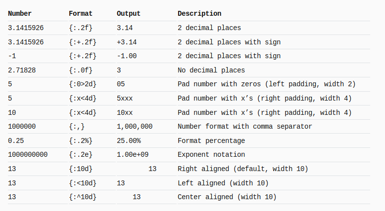
df['CumulativeDist']=ds Let's plot!
df.plot(kind='line',x='CumulativeDist',y='Heartrate',color='red')
plt.show() 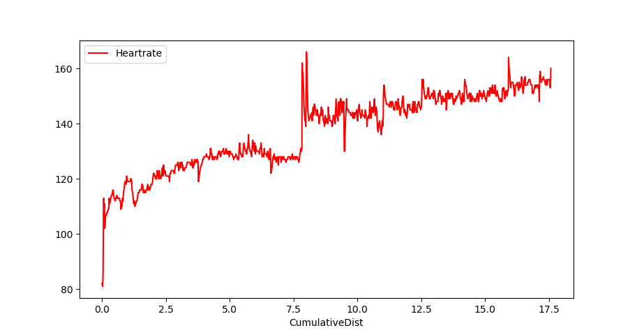
Or multiple columns:
plt.plot( df.CumulativeDist, df.Heartrate, color='red')
plt.plot( df.CumulativeDist, df.Altitude, color='blue')
plt.show()
Turn a dataframe into an array
eg. dataframe cn
cn

                     asciiname  population  elevation
128677                Crossett        5507         58
7990    Santa Maria da Vitoria       23488        438
25484                 Shanling           0        628
95882     Colonia Santa Teresa       36845       2286
38943                 Blomberg        1498          4
7409              Missao Velha       13106        364
36937                  Goerzig        1295         81
Turn into an arrary
cn.iloc[range(len(cn))].values


array([['Yuhu', 0, 15],
       ['Traventhal', 551, 42],
       ['Velabisht', 0, 60],
       ['Almorox', 2319, 539],
       ['Abuyog', 15632, 6],
       ['Zhangshan', 0, 132],
       ['Llica de Vall', 0, 136],
       ['Capellania', 2252, 31],
       ['Mezocsat', 6519, 91],
       ['Vars', 1634, 52]], dtype=object)
Sidenote: cn was pulled from city data: cn=df.sample(7)[['asciiname','population','elevation']].
Filter a dataframe to retain rows with non-null values
Eg. you want only the data where the 'population' column has non-null values.
In short
df=df[df['population'].notnull()]Alternative, replace the null value with something:
df['population']=df['population'].fillna(0) In detail
import numpy as np
import pandas as pd

# setup the dataframe
data=[[ 'Isle of Skye',         9232, 124 ],
      [ 'Vieux-Charmont',     np.nan, 320 ],
      [ 'Indian Head',          3844,  35 ],
      [ 'Cihua',              np.nan, 178 ],
      [ 'Miasteczko Slaskie',   7327, 301 ],
      [ 'Wawa',               np.nan,   7 ],
      [ 'Bat Khela',           46079, 673 ]]

df=pd.DataFrame(data, columns=['asciiname','population','elevation'])

#display the dataframe
df

            asciiname  population  elevation
0        Isle of Skye      9232.0        124
1      Vieux-Charmont         NaN        320
2         Indian Head      3844.0         35
3               Cihua         NaN        178
4  Miasteczko Slaskie      7327.0        301
5                Wawa         NaN          7


# retain only the rows where population has a non-null value
df=df[df['population'].notnull()]

            asciiname  population  elevation
0        Isle of Skye      9232.0        124
2         Indian Head      3844.0         35
4  Miasteczko Slaskie      7327.0        301
6 Bat Khela 46079.0 673List EXIF details of a photo
This program walks a directory, and lists selected exif data.
Install module exifread first.
1 2 3 4 5 6 7 8 9 10 11 12 13 14 15 16 17 18 19 20 21 22 23 24 25 26 | |
The topics of the kubercon (Kubernetes conference)
Input
Markdown doc 'source.md' with all the presentation titles plus links:
[2000 Nodes and Beyond: How We Scaled Kubernetes to 60,000-Container Clusters
and Where We're Going Next - Marek Grabowski, Google Willow
A](/event/8K8w/2000-nodes-and-beyond-how-we-scaled-kubernetes-to-60000
-container-clusters-and-where-were-going-next-marek-grabowski-google) [How Box
Runs Containers in Production with Kubernetes - Sam Ghods, Box Grand Ballroom
D](/event/8K8u/how-box-runs-containers-in-production-with-kubernetes-sam-
ghods-box) [ITNW (If This Now What) - Orchestrating an Enterprise - Michael
Ward, Pearson Grand Ballroom C](/event/8K8t/itnw-if-this-now-what-
orchestrating-an-enterprise-michael-ward-pearson) [Unik: Unikernel Runtime for
Kubernetes - Idit Levine, EMC Redwood AB](/event/8K8v/unik-unikernel-runtime-
..
..
Step 1: generate download script
Grab the links from 'source.md' and download them.
#!/usr/bin/python
# -*- coding: utf-8 -*-

import re

buf=""
infile = file('source.md', 'r')
for line in infile.readlines():
    buf+=line.rstrip('\n')

oo=1
while True:
    match = re.search( '^(.*?\()(/.[^\)]*)(\).*$)', buf)
    if match is None:
        break
    url="https://cnkc16.sched.org"+match.group(2)
    print "wget '{}' -O {:0>4d}.html".format(url,oo)
    oo+=1
    buf=match.group(3)
Step 2: download the html
Execute the script generated by above code, and put the resulting files in directory 'content' :
wget 'https://cnkc16.sched.org/event/8K8w/2000-nodes-and-beyond-how-
      we-scaled-kubernetes-to-60000-container-clusters-and-where-were-
      going-next-marek-grabowski-google' -O 0001.html
wget 'https://cnkc16.sched.org/event/8K8u/how-box-runs-containers-in-
      production-with-kubernetes-sam-ghods-box' -O 0002.html
wget 'https://cnkc16.sched.org/event/8K8t/itnw-if-this-now-what-
      orchestrating-an-enterprise-michael-ward-pearson' -O 0003.html
..
Step 3: parse with beautiful soup
#!/usr/bin/python
# -*- coding: utf-8 -*-

from BeautifulSoup import *
import os
import re
import codecs

#outfile = file('text.md', 'w')
# ^^^ --> UnicodeEncodeError:
#                'ascii' codec can't encode character u'\u2019'
#                in position 73: ordinal not in range(128)
outfile= codecs.open("text.md", "w", "utf-8")

file_ls=[]
for filename in os.listdir("content"):
    if filename.endswith(".html"):
        file_ls.append(filename)

for filename in sorted(file_ls):
    infile = file('content/'+filename,'r')
    content = infile.read()
    infile.close()
    soup = BeautifulSoup(content.decode('utf-8','ignore'))

    div= soup.find('div', attrs={'class':'sched-container-inner'})
    el_ls= div.findAll('span')

    el=el_ls[0].text.strip()
    title=re.sub(' - .*$','',el)
    speaker=re.sub('^.* - ','',el)

    outfile.write( u'\n\n## {}\n'.format(title))
    outfile.write( u'\n\n{}\n'.format(speaker) )

    det= div.find('div', attrs={'class':'tip-description'})
    if det is not None:
outfile.write( u'\n{}\n'.format(det.text.strip() ) )Incrementally update geocoded data
Startpoint: we have a sqlite3 database with (dirty) citynames and country codes. We would like to have the lat/lon coordinates, for each place.
Here some sample data, scraped from the Brussels marathon-results webpage, indicating the town of residence and nationality of the athlete:
LA CELLE SAINT CLOUD, FRA
TERTRE, BEL
FREDERICIA, DNK
But sometimes the town and country don't match up, eg:
HEVERLEE CHN
WOLUWE-SAINT-PIERRE JPN
BUIZINGEN FRA
For the geocoding we make use of nominatim.openstreetmap.org. The 3-letter country code also needs to be translated into a country name, for which we use the file /u01/data/20150215_country_code_iso/country_codes.txt.
The places for which we don't get valid (lat,lon) coordinates we put (0,0).
We run this script multiple times, small batches in the beginning, to be able see what the exceptions occur, and bigger batches in the end (when problems have been solved).
In between runs the data may be manually modified by opening the sqlite3 database, and updating/deleting the t_geocode table.
1 2 3 4 5 6 7 8 9 10 11 12 13 14 15 16 17 18 19 20 21 22 23 24 25 26 27 28 29 30 31 32 33 34 35 36 37 38 39 40 41 42 43 44 45 46 47 48 49 50 51 52 53 54 55 56 57 58 59 60 61 62 63 64 | |
A few queries
Total number of places:
select count(1) from t_geocode
916
Number of places for which we didn't find valid coordinates :
select count(1) from t_geocode where lat=0 and lon=0
185Turn a pandas dataframe into a dictionary
eg. create a mapping of a 3 digit code to a country name
BEL -> Belgium
CHN -> China
FRA -> France
..
Code:
df=pd.io.parsers.read_table(
    '/u01/data/20150215_country_code_iso/country_codes.txt',
    sep='|')

c3d=df.set_index('c3')['country'].to_dict()
Result:
c3d['AUS']
'Australia'

c3d['GBR']
'United Kingdom'Create a DB by scraping a webpage
Download all the webpages and put them in a zipfile (to avoid 're-downloading' on each try).
If you want to work 'direct', then use this to read the html content of a url:
html_doc=urllib.urlopen(url).read()Preparation: create database table
cur.execute('DROP TABLE IF EXISTS t_result')

cur.execute('''
CREATE TABLE t_result(
        pos  varchar(128),
        nr  varchar(128),
        gesl varchar(128),
        naam varchar(128),
        leeftijd varchar(128),
        ioc varchar(128),
        tijd varchar(128),
        tkm varchar(128),
        gem varchar(128),
        cat_plaats varchar(128),
        cat_naam varchar(128),
        gemeente varchar(128)
        )
''') ##
Pull each html file from the zipfile
zf=zipfile.ZipFile('brx_marathon_html.zip','r')
for fn in zf.namelist():
    try:
        content= zf.read(fn)
        handle_content(content)
    except KeyError:
        print 'ERROR: %s not in zip file' % fn
        break
Parse the content of each html file with Beautiful Soup
soup = BeautifulSoup(content)

table= soup.find('table', attrs={'cellspacing':'0', 'cellpadding':'2'})
rows = table.findAll('tr')
for row in rows:
    cols = row.findAll('td')
    e = [ ele.text.strip()  for ele in cols]
    if len(e)>10:
        cur.execute('INSERT INTO T_RESULT VALUES ( ?, ?, ?, ?, ?, ?, ?, ?, ?, ?, ?,? )',
                    (e[0],e[1],e[2],e[3],e[4],e[5],e[6],e[7],e[8],e[9],e[10],e[11]) )
Note: the above code is beautiful soup 3, for beautiful soup 4, the findAll needs to be replaced by find_all.
Complete source code
1 2 3 4 5 6 7 8 9 10 11 12 13 14 15 16 17 18 19 20 21 22 23 24 25 26 27 28 29 30 31 32 33 34 35 36 37 38 39 40 41 42 43 44 45 46 47 48 49 50 51 52 53 54 55 56 57 58 59 | |
Days between dates
Q: how many days are there in between these days ?
'29 sep 2016', '7 jul 2016', '28 apr 2016', '10 mar 2016', '14 jan 2016'Solution:
from datetime import datetime,timedelta

a=map(lambda x: datetime.strptime(x,'%d %b %Y'),
      ['29 sep 2016', '7 jul 2016', '28 apr 2016', '10 mar 2016', '14 jan 2016'] )

def dr(ar):
    if len(ar)>1:
        print "{:%d %b %Y} .. {} .. {:%d %b %Y} ".format(
                            ar[0], (ar[0]-ar[1]).days, ar[1])
        dr(ar[1:])
Output:
dr(a)

29 Sep 2016 .. 84 .. 07 Jul 2016
07 Jul 2016 .. 70 .. 28 Apr 2016
28 Apr 2016 .. 49 .. 10 Mar 2016
10 Mar 2016 .. 56 .. 14 Jan 2016